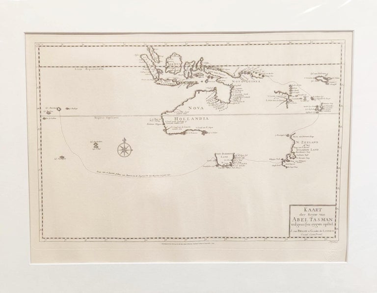
Kaart der Reyse van Abel Tasman, volgens syn eygen opstel
Canberra: Australian Institute of Cartographers, (1726) 1985. Limited edition, No.29 of 250, engraved map, 315mm x 470mm, with the blind-stamp of the Australian Institute of Cartographers. Near fine condition
Chart reproduced from a copy in the Rare Map Collection, National Library of Autralia. Documenting Tasman's 1642-43 voyage in which Tasmania and New Zealand were discovered, and the 1644 voyage during which much of the northern coastline of Australia was documented. Shows Tasman's route from Mauritius to Van Diemen's Land, New Zealand to Java. 'Nova Hollandia' is included although the eastern and south eastern coasts are yet to be explored. Many rivers on eastern cape York and Gulf of Carpentaria have been named. Text in Dutch. The original was first issued in Francois Valentyn's eight volume work 'Oud En Nieuw Oost Indien,' published 1724-1726. Valentyn (1666-1727) was a Reformist Minister and served with the Dutch East India Company. He made numerous voyages to the East Indies and his important work on the region provided insight into local culture. During compilation of his work Valentyn was given access to many of the companies archives, including the charts of Tasman. Item #99756
Price (AUD):
$495.00
Other currencies